Thomas Jefferson played an important role in the development of Detroit. If Jefferson had not believed in the expansion of the United States and strongly favored the use of federal government resources to foster internal development, Detroit and Michigan might have emerged much more slowly. It is even possible that had Jefferson not had imagination, what we know as Michigan would be a few northern counties of Indiana. And the Upper Penninsula would be the northern counties of Wisconsin. Jefferson had persistent interests in the westward expansion of the United States. He led efforts to purchase, from the French, the central heartlands of the United States; efforts accomplished with the Louisiana Purchase in 1803 which just about doubled the geographic size of the nation. No longer were Louisiana, Arkansas, Missouri, Iowa, Nebraska and Minnesota French colonies.
It was Thomas Jefferson who appointed Augustus Woodward of Virginia to serve as the first federal judge in the Michigan Territory. Woodward had great aspirations for Detroit and hoped that it would become the leading metropole in what was then known as the Northwest Territories. Perhaps, with ideas of urban greatness in mind, it was Woodward who selected Pierre L’Enfant’s plan for the city of Washington as a model for the urban plan still found in downtown Detroit. Jefferson was the individual who selected L’Enfant to design the Washington we know today. It is fitting an appropriate that the major thoroughfare along the city's waterfront - sketched out by Judge Woodward - bear the name of Jefferson.
Jefferson had a persistent interest in economic growth in the United States but he realized that there was a major problem. At its founding, almost all of the nation’s population and economic activities were east of the formidable Alleghany mountains. After the Revolutionary War, numerous people began crossing those mountains and settled the area that became the Northwest Territories. One very severe problem was hostility from Indians, but by the early 1890s, President Washington reluctantly sent troops to the Midwest to confine and control the Indians who still cooperated with and were supplied armaments by the British from their forts at Detroit and the straits of Mackinac. After General Anthony Wayne defeated the Indians at the Battle of Fallen Timbers near present-day Toledo on August 20, 1794, the Indians were less of a threat. They realized that they really could not depend upon the British in their battles with United States forces. Eventually the British were willing to relinquish their claim on the area we now know as Indiana, Ohio and Indiana. The United States and the United Kingdom signed Jay’s Treaty in 1795 and, on July 13, 1796, Colonel Jean François Hamtramck peacefully led United States troops who took over Detroit from the British.
On October 13, 1804, three hundred Detroit men signed a petition asking Congress to establish a new Michigan territory. At the time the asrea we know as Michigan was a northern component of Indiana Territory. President Jefferson endorsed the idea so his colleagues in Congress enacted the requisite legislation. On January 11, 1805; Thomas Jefferson signed the documents creating a Michigan territory with an initiation date of July 1, 1805. Little attention was paid to the exact drawing of the line separating Indiana from Ohio leading to controversy in the early 1830s when Michigan sought to become a state. After much conflict and political pressure Michigan, surrendered its claim on the mouth of the Maumee but was rewarded with the Upper Peninsula.
Militant American natives were one serious problem for settlers west of the Alleganies. But there was another: transportation. Products could be grown in abundance west of those formidable mountains but there was no easy way to get them to markets along the East Coast. In some circumstance, products could be shipped down the Ohio and Mississippi Rivers and then across the Gulf of Mexico to east coast ports but that was a very long and expensive trip.
The idea of building a canal west from Washington to Cumberland Maryland and then on to the Ohio River or one of its tributaries was discussed during President George Washington administration, but work was not started. There were issues of cost and also the fundamental engineering challenging of digging a canal across the steep Alleghany Mountains and then supplying it with flowing water. Was such a canal possible?
Thomas Jefferson drafted the Declaration of Independence in 1776. From 1784 to 1789, Jefferson lived in France serving, for part of that time, as United States minister to that country. He did not become President of the United States until 1801. In 1787, he decided to take a long trip through southern France and northern Italy as a private person. Being an extremely inquisitive person, Jefferson wished to study agricultural practices, the local economies, the types of wines grown in different regions and architecture. At Niems in southern France, he visited Maison Carrée, a Roman Temple that served him as a model for the capitol of Virginia that Jefferson designed.
Jefferson kept careful notes of what he viewed in this long 1787 journey. He was interested in the Canal de Languedoc which is now called the Canal du Midi. South central France—extending from the Mediterrean north of the Pyrenees toward Bordeaux was, and is, a very productive area with especially fertile fields devoted to grapes and olives. But this verdant area was somewhat isolated so there was the same challenge that confronted the new United States. How to get products and commerce from one isolated productive place to markets?
Apparently, the Romans were the first to propose a canal across southern France extending from the Mediterrean to some point on the River Garonne, a river that empties into an estuary of the Atlantic at Bordeaux. The Romans and the Medieval French potentates did not have the resources to build such a canal. King Louis XIV did. And he found a designer who was willing to take on the massive project of constructing a canal across southern France: Pierre-Paul Riquet. Riquet was born about 1605 near Beziers. His father held an appointment as a notary—a significant governmental official at the time. Riquet got an appointment from the French crown to collect the federal tax on salt in his area. Somehow he became very rich. But he was also interested in designing, investing in and then building the canal that the Romans had sketched out. He knew that a canal from Toulouse to the Mediterrean would be valuable, but also saw the great value of a canal west from Toulouse toward Bordeaux and the Atlantic.
His first engineering problem was to find the exact high point of land in that stretch of southern France, a place where he might create a lake that would supply the requisite water to keep the canals to both the Mediterrean and the Atlantic filled all year. He located that spot, making canal construction possible. In about 1666, he secured approval and financial support from King Louis XIV and his minister Colbert to begin constructing the 241 kilometer canal that extended from Sete on the Mediterrean to Toulouse. French governmental leaders, for centuries, recognized the value of such a canal since it would no longer be necessary to ship products from around Iberia to get them from southern to northern France. And, from time to time, the French and Spanish were at war.
It took Riquet only fourteen years to build the long and well-designed canal. He died, alas, in October, 1680. The canal was opened for business on May 24 of the next year. With the Canal du Midi in operation, agricultural products could much more easily and cheaply be shipped to Medeterian ports and then on to other markets. The Canal du Midi is, arguably, the most impressive late medieval engineering project in Europe.
Riquet had interest in extending his canal to the Atlantic but he died before construction could begin and Louis XIV apparently ran out of funds for such internal improvement, perhaps because of the great expenses he made to create his palaces at Versailles.
Thomas Jefferson, I presume, wondered if a similar canal could be built west from Washington to the Ohio River, one that would allow the products of the fertile Midwest reach the populous eastern markets. Thus, Jefferson toured the canal. I think that he made some of his trips along the canal by the barges that were pulled by animals but also traveled by carriage at some points. It took him nine days to travel the 240 kilometers from Sete—where the canal joins the Mediterrean Sea—to Toulouse.
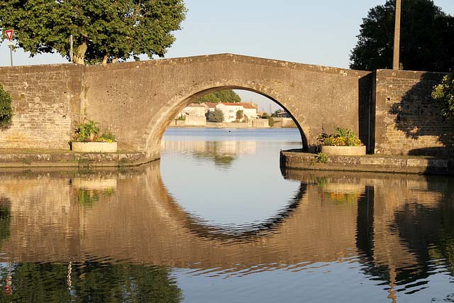
Thomas Jefferson kept detailed notes on his travels so we know he visited Carcassonne and Castelnaudary on May 18, 1787. Presumably, he passed under or walked across the bridge that Pierre-Paul Riquet designed. Indeed, it was more than a century old at that time. I had the honor of walking across this historic bridge on May 30, 2016, just 229 years after Jefferson did. As you might expect, Riquet used a standard design for his bridges so there are many Canal de Midi bridges resembling the one you see here. Each of them is named. But no other Canal du Midi bridge has an historic plaque commemorating Thomas Jefferson for his writing of the Declaration of Independence and for his inquisitiveness about infrastructure investments.
A final note on the three major canals mentioned on this page: A canal to cross the Alleghenies was finally funded in the final months of the Monroe administration and construction began in 1828. Just twenty-two years later, the 297-kilometer Chesapeake and Ohio Canal was completed linking Washington, DC to Cumberland, Maryland. By that time, railroads were proving to be much more efficient and much less expensive than canals for the transport of passengers and freight. Thus the canal was not extended to the west.
In 1838, some 154 years after Riquet completed the Canal du Midi for King Louis XIV; the French government decided to continue canal building and dug the Canal du Garonne from Toulouse to Castets-en-Dorthe near Bordeaux. It has a length of 194 kilometers and was completed in 1856 but, by that time, railroads were proving to be a much better mode of transportation.
At present, these three canals are still in operation—at least to some extent—but for pleasure boats rather than for commercial shipping. I have run, walked or ridden a bicycle along the tow paths of all these canals. The path along the Chesapeake and Ohio canal is, for the most part, in quite good shape. Most of the path along the Canal du Garonne is pleasantly passable since it is tarmac. The path along the Canal de Midi is terrible and, until it is improved, should be avoided.
Builder/architect for Canal du Midi and bridge at Castelnaudary: Pierre-Paul Riquet
Date of construction: About 1667
Use in 2016: Bridge for vehicles and pedestrians
Picture: Ren Farley; May, 2016
Description updated: January, 2017
Return to Transportation
Return to Homepage